 |
|||||||||||
|
|
|||||||||||
|
FREQUENTLY ASKED QUESTIONS Click on any of the titles below for more information.
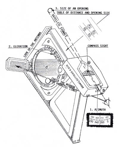
Find the Elevation. Find the Satellite Signals. Determinate the Size of an Opening and the Distance away. What kind of tasks can I perform with the 4.5m Site & Satellite Finder Survey Kit? 2) Azimuth and Elevation "Look Angle" Setting simultaneously for satellite antenna from 0.3m to 4.0m (1 to 13 feet). Extra extension Alignment Scales might be needed. Because the Site & Satellite Finder can be placed below the antenna dish the compass will give a correct reading for MAGNETIC as well as for NON-MAGNETIC satellite antennas. You need to know (at your location) the Azimuth adjusted for the declination (Magnetic north) and the Elevation Look Angle for each satellite you would like to receive signals from. 3) Traditional setting of plumb pole and axis with the magnetic based INOGON in the back of the antenna. The Site & Satellite Finder Survey kit (Order No. 170505) complete consists of:
Sighting INOGON, SILVA Precision Sighting Compass, 250m (10") Magnetic Base with hook, 600mm (2 ft.) DirecTV Alignment Scale with hook, 1.2m (4ft) Alignment
Scale with hook, (4.5M Kit icludes 3 Alignment Scale Extensions each 1.14m (45")) and Compact Tripod. Comes in a protective carrying case. What kind of tasks can I perform with the Laser Directed Site & Satellite Finder? 2) Laser Directed Site survey in low light condition. The satellite signals can be visualized and the laser point can be seen 45m (150 ft.) in shaded areas and 300m (1000 ft.) in darkness. The laser will point out if any obstacles are in the way of the satellite signals. 3) Laser Directed Elevation Setting for the "Look Angle" and Azimuth of satellite antennas from 0.3m to 18m (1 to 60 ft.). The dish antenna can be checked for all the different pre-programmed settings. 4) Traditional setting of plumb pole and axis with the magnetic based INOGON in the back of the antenna. The Laser Directed Site & Satellite Finder kit (Order No. 170601) consists of: Sighting
INOGON, SILVA Precision Sighting Compass, Laser Projector, Reflective Antenna Face Target, 250mm (10") Magnetic Base, Dish Clamp and Compact Tripod. Comes in a protective case. GPS Directed 3-D Precision Site & Satellite Finder. The Global Positioning System was developed for the US Department of Defense as a high-accuracy navigational and targeting system. GPS units on earth lock onto high-frequency radio signals from some of the 24 GPS satellites and calcuate through triangulation the exact location of the unit (and user). The Defense Department made GPS available to civilian use and today some antenna manufacturers include this instrument in large antenna installations. With the Azimuth and Elevation at the location, this instrument will show where the satellite signals are emitting from. Also, it will show the width of an opening between buildings, trees or other obstacles for the signals to pass through. For example, if you have a 3 meter antenna you will like to have it be exposed to a 3 meter wide signal. This new instrument is designed for site survey and aiming Ku-band (DirecTV, Primestar, Digital Music Express (DMX) as well as C-band antenna. The installer can view a projection of the Azimuth and Elevation degrees simultaneously of incoming signals as well as measure and adjusting the antenna for the Azimuth and the Look Angle. The GPS Directed 3-D Precision Site & Satellite Finder can be used worldwide. Depending on your location the Azimuth must be adjusted for magnetic north calculated
by the GPS unit; ie. Boston, Massachusetts add 16 degrees, San Francisco, California deduct 16 degrees. The reading is extremely accurate (Location (Latitude/Longitude)
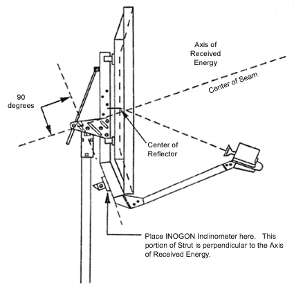
+/- 5 meters; AZ +/- 0.5 degrees; and EL +/- 0.1 degree). Placement of the INOGON Elevation Finder on the Prodelin 1.8m antenna for setting the elevation.
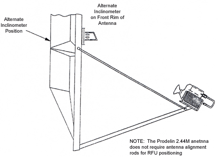
Setting antenna elevation on the Prodelin 2.44 meter dish. To set the elevation on the Prodelin 2.44 quick repoint antenna, take the elevation angle from the LAT/LONG program and subtract 22.3 degrees from this value. The difference is the desired inclinometer reading. Place the inclinometer on the flat front rim of the antenna, as shown in the figure below. Position the inclinometer so it is orientated vertically as the antenna is viewed from the front. Because the reflector surface is made of fiberglass, the inclinometer magnets will not hold the inclinometer in place. Therefore you will need to use a dish alignment scale with hook.
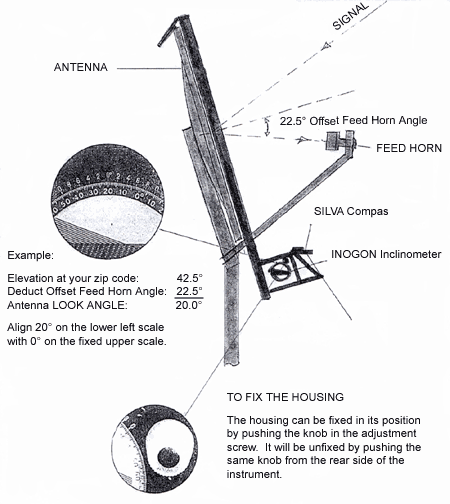
Calculation of Look Angel for an antenna with offset feed horn.
3-D Site & Satellite Finder for DirecTV. The Site & Satellite Finder fits right into the first two steps of the three step calibration procedure.
Off Air Antenna Aiming |
|||||||||||
|
|||||||||||

|
|
|
